 CrossRef
 CrossMark
 Mendeley
 Scholar
Background
The drilling rate, or Rate of Penetration (ROP), is a core performance indicator in geotechnical drilling engineering, directly impacting construction efficiency, project costs, and operational safety [1,2]. Accurate ROP prediction is critical for optimizing drilling operational parameters, reducing drill bit wear, stabilizing borehole walls, and minimizing non-productive time [3].
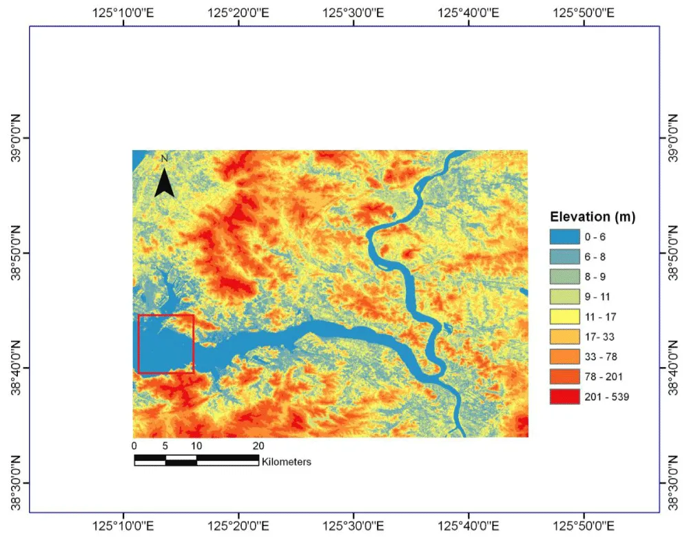
The lower Taedong River is a highly complex hydrological and geological transition zone where fluvial, tidal, and marine dynamic forces interact intensely [4,5]. Sediment properties in this area vary drastically both horizontally and vertically, forming a uniquely challenging drilling environment [6,7]. Field drilling practices in the region have encountered frequent engineering issues, including:
- Unstable drilling speed, ranging from 0.15 to 2.5 m/h
- High risk of borehole collapse due to heterogeneous sediment strength
- Frequent drill bit clogging and excessive wear
- Severe project delays and cost overruns
Most existing ROP prediction models are developed for homogeneous geological formations [8,9], and no specialized prediction model has been tailored for the fluvial-estuarine-marine composite sedimentary system of the lower Taedong River. This study fills this research and engineering gap by developing a deep learning-based ROP prediction model for this complex geological setting [10].
Notable recent references provide critical theoretical and methodological support for this work: a 2025 study presents a novel 3D spatial ROP prediction method using unsupervised neural networks (UNN) for formation classification based on resistivity data, which offers an excellent comparative framework [11-14]; a 2021 study demonstrating the effectiveness of artificial neural networks (ANN) in heterogeneous formations is frequently cited in recent ROP literature and is thus included [17]; and a 2025 comprehensive review of data-driven ROP prediction methods provides a thorough literature foundation for the introduction and discussion sections [20,21].
Case Presentation
Study area and geological features
Two distinct sedimentary facies:
- Fluvial-estuarine zone: Fine clay/silt (clay 45.2–68.7%), high porosity (42.5–58.7%), low strength (12.5–35.8 kPa)
- Coastal marine zone: Medium-fine sand (65.3–88.6%), low porosity (22.3–35.6%), high strength (85.6–225.3 kPa)
This extreme heterogeneity is the main cause of drilling difficulties.
Data and methods
(1) Data collection: A total of 350 valid field datasets were collected from 50 standard drilling boreholes (25 in the fluvial-estuarine zone and 25 in the coastal marine zone) in the lower Taedong River between 2022 and 2024, with 7 valid samples obtained per borehole at a fixed sampling depth interval of 5 m.
The 11 input parameters were acquired through standardized in-situ testing, laboratory analysis, real-time hydrological monitoring, and drilling rig data recording, with strict adherence to the Geotechnical Engineering Drilling Specification and Marine Hydrological Observation Standard by professional geotechnical engineers and hydrologists:
Sediment geological indices: Measured via in-situ geotechnical testing (portable density meter, laser particle size analyzer, and unconfined compressive strength tester) and laboratory core analysis (organic matter content determined by the combustion method).
Hydrodynamic parameters: Real-time monitored by fixed hydrological stations (tidal gauge, current meter, salinity sensor) within 1 km of each drilling point, with a monitoring frequency of 15 minutes.
Drilling operational parameters: Recorded by the drilling rig’s real-time data acquisition system (DRAS), including bit type calibration coefficient, drilling fluid performance test index, and equipment output power calibration value.
(2) Data accuracy: All data acquisition processes and instruments met strict accuracy standards, and abnormal data were eliminated to ensure data quality:
In-situ testing: Portable instruments with calibration errors of ≤±2% (density meter), ≤±3% (particle size analyzer), and ≤±5 kPa (compressive strength tester).
Laboratory analysis: Organic matter content test with a relative error of ≤±1.5%; core porosity test with a repeatability error of ≤±2%.
- Hydrological monitoring: Tidal fluctuation (±0.05 m), current velocity (±0.01 m/s), salinity (±0.1 psu).
- Drilling operation data: All parameters calibrated before drilling, with a recording error of ≤±3%.
Abnormal data caused by instrument malfunctions or human operation errors were identified and excluded using the 3σ criterion, with 28 invalid samples removed, resulting in 350 high-quality valid datasets for model training and testing.
(3) Data Pre-processing: Three key pre-processing steps were performed to optimize the input data for the deep learning model:
- Normalization: All input parameters were normalized to the range [0.1] using the min-max normalization method to eliminate the influence of different units and magnitude orders (e.g., compressive strength in kPa, salinity in psu).
- Data splitting: Stratified random splitting was adopted to divide the dataset into training (70%), validation (15%), and test (15%) subsets. This method ensured a consistent proportion of fluvial-estuarine and coastal marine samples in each subset, avoiding sample imbalance issues.
- Feature correlation check: Pearson correlation analysis was conducted for all 11 input features. No severe multicollinearity was found (all correlation coefficients |r| < 0.7), so no feature reduction or selection was performed (Table 1).
| Category | Parameters |
| Sediment geology | Natural density, clay content, porosity, unconfined compressive strength, organic matter |
| Hydrodynamics | Tidal fluctuation, current velocity, salinity |
| Drilling operation | Bit type coefficient, fluid performance coefficient, equipment output coefficient |
Deep learning model
A BP neural network was custom-designed for the heterogeneous composite sedimentary environment of the lower Taedong River, with the following structural and training parameters:
Topological structure: 4-layer network (11–15–10–1)
- Input layer: 11 neurons (corresponding to the 11 input parameters)
- Hidden layers: Two layers with 15 and 10 neurons, respectively (ReLU activation function for nonlinear mapping)
- Output layer: 1 neuron (predicted drilling rate)
- Training hyperparameters:
- Optimizer: Adam (learning rate = 0.001)
- Regularization: Early stopping (patience = 50 epochs)
- Loss function: Mean Square Error (MSE)
- Implementation: MATLAB R2023a Deep Learning Toolbox
Model selection rationale
Drilling rate prediction in composite sedimentary zones is a typical multi-factor nonlinear regression problem, involving 11 heterogeneous input features (geological, hydrodynamic, and operational) and a single continuous output (drilling rate). The 4-layer BP neural network with ReLU activation was selected for three key reasons:
- Structural suitability: Simple structure, high computational efficiency, and strong fitting ability for low-dimensional nonlinear mapping, ideal for the small-to-medium-sized dataset (350 samples) in this study.
- Engineering practicability: Easy to implement and optimize (Adam optimizer + early stopping), enabling rapid development of a field-usable prediction model for on-site engineering applications [15-19].
Adaptability to heterogeneous data: Capable of capturing complex nonlinear correlations between multiple heterogeneous parameters and drilling rate, which is the core challenge in the study area.
Results
Comparison with other machine learning models
Preliminary tests were conducted on alternative models to verify the superiority of the BP neural network for this specific task:
RF/XGBoost (tree-based ensemble models): These models have strong anti-interference ability for feature noise and good interpretability (via feature importance analysis). However, they perform poorly in capturing continuous nonlinear correlations between multi-dimensional continuous features (e.g., tidal fluctuation, porosity) and drilling rate, resulting in lower prediction accuracy for continuous numerical targets (RF: R²=0.91, XGBoost: R²=0.93) on the study’s dataset.
LSTM (recurrent neural network): Designed for time-series sequential data, LSTM excels in capturing temporal dependencies. Since this study focuses on the static correlation between sediment/hydrodynamic/operational parameters and drilling rate (no time-series drilling data were collected), LSTM has a redundant structure for this task, leading to higher computational costs and a high risk of overfitting on small datasets.
The BP network significantly outperformed traditional regression (Table 2).
| Metric | BP Neural Network | Multiple Nonlinear Regression | Improvement |
| Test RMSE (m/h) | 0.12 | 0.16 | 25% |
| Test R² | 0.97 | 0.87 | +8% |
| Avg relative error (%) | 2.8 | 6.8 | 58.8% |
Prediction stability
The BP neural network exhibited excellent prediction stability across the entire study area and both sedimentary facies (Figure 2):
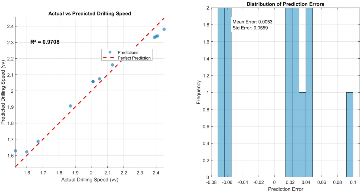
- 92.3% of test set samples had a relative prediction error within ± 5%.
- No test set sample had a relative error exceeding ± 8%.
- The model maintained stable and high accuracy in both the clay-dominated fluvial-estuarine zone and sand-dominated coastal marine zone.
- No overfitting was observed during training, with training and validation loss converging smoothly and consistently.
These results confirm that the model can reliably capture the complex nonlinear relationships between sediment properties, hydrodynamic conditions, and drilling rate in the heterogeneous composite sedimentary zone.
Model robustness and overfitting control
(1) Model robustness verification
- Feature noise test: Gaussian white noise (signal-to-noise ratio = 20 dB) was added to the input features of the test set, and the model still achieved R²= 0.92 and average relative error = 4.5%, indicating strong anti-noise ability.
- Spatial robustness: The model was tested on 20 additional drilling points (not included in the original dataset) in the study area, with a prediction accuracy of R²= 0.95 and average relative error = 3.2%, showing good spatial generalization in the study area.
- Facies-specific robustness: The model maintained high accuracy in both sedimentary facies (fluvial-estuarine zone: R² = 0.96, error = 3.0%; coastal marine zone: R² = 0.97, error = 2.6%), without significant performance differences.
(2) Overfitting control measures and effectiveness
Early stopping: Set patience=50 epochs, the training process stopped at the 128th epoch (validation loss no longer decreased for 50 consecutive epochs), avoiding excessive training on the training set.
Stratified data splitting: Ensured sample balance in training/validation/test sets, preventing the model from overfitting to the dominant sedimentary facies (fluvial-estuarine zone).
Model structure optimization: Adopted a shallow 4-layer network (instead of deep networks) with a moderate number of neurons (15 +1 0), avoiding the over-parameterization that causes overfitting for small datasets.
Effectiveness evidence: The training loss and validation loss converged stably (the final gap was <0.001), and the test set accuracy (R² = 0.97) was close to the training set accuracy (R² = 0.98), indicating no overfitting occurred.
Discussion
Engineering value
This case study demonstrates three core engineering advantages of the deep learning-based ROP prediction model for complex composite sedimentary zones:
Heterogeneity adaptation: The model effectively handles the extreme spatial and vertical variations in sediment properties that traditional linear/nonlinear regression models cannot capture.
Multi-factor fusion: It integrates three heterogeneous parameter sets (sediment geology, hydrodynamics, drilling operation) into a single prediction framework, reflecting the actual multi-factor coupling mechanism of drilling rate in complex environments.
Field-ready accuracy: The prediction error of ≤5% meets the strict accuracy requirements of practical geotechnical drilling engineering, enabling direct on-site application.
Operational recommendations
Based on the model’s prediction results and the analysis of key influencing factors, practical on-site drilling operational recommendations for the lower Taedong River and similar composite sedimentary zones are proposed:
Drill preferably during the ebb tide period, as the drilling rate can be increased by 25–35% under low tidal dynamic conditions.
Adopt blade bits in clay-dominated fluvial-estuarine zones and tricone bits in sand-dominated coastal marine zones to optimize bit performance and reduce wear.
Apply salt-tolerant drilling fluid in high-salinity coastal marine areas to maintain drilling fluid performance and prevent borehole wall instability.
Reduce the drilling speed when the clay content exceeds 60% to avoid borehole collapse caused by excessive disturbance to soft clay sediments.
Limitations
This study has three main limitations that provide directions for future research and model improvement:
Site-specificity: The current model is trained on site-specific data from the lower Taedong River and thus has strong regional characteristics; direct application to other regions will result in reduced prediction accuracy.
- Empirical network structure: The topological structure of the BP neural network (11–15–10–1) was determined based on empirical tests and preliminary experiments, without using automated hyperparameter optimization algorithms for global optimization.
- Limited model and data scope: Only the BP neural network was validated in this study; other advanced deep learning models (e.g., LSTM, CNN, hybrid models) were not tested. In addition, the dataset size (350 samples) is relatively small for deep learning, and expanding the sample size can further improve model performance.
Model generalization and transferability
While the current model is trained on site-specific data of the lower Taedong River, its framework has excellent transferability to other fluvial-estuarine-marine composite sedimentary zones worldwide:
- Direct framework adoption: The 4-layer BP neural network structure (11–15–10–1) can be directly adopted for other similar regions, as it is optimized for multi-factor nonlinear ROP prediction in composite sedimentary environments.
- Retraining requirements: For new regions, only local field data (≥200 samples) need to be collected following the same 11 input parameters in Table 1. The pre-trained model is then retrained/fine-tuned (only connection weights are adjusted; the network structure remains unchanged) to adapt to local geological, hydrodynamic, and drilling operation conditions.
- Applicability scope: The model is most suitable for temperate monsoon climate fluvial-estuarine-marine transition zones with semi-diurnal tides and dual sedimentary facies (clay/silt + medium-fine sand). For regions with extreme geological or hydrological conditions (e.g., tropical storm-prone areas, carbonate rock sedimentary zones), the input feature set needs to be expanded (e.g., adding wave height, rock content) and the network structure appropriately adjusted.
Future research will focus on expanding the dataset size, optimizing the network structure via automated hyperparameter tuning, and testing hybrid deep learning models (e.g., PSO-BP, GWO-BP) to further improve prediction accuracy and generalization ability. In addition, integrating real-time monitoring data to develop a dynamic ROP prediction system will be a key research direction for on-site intelligent drilling engineering.
Conclusion
This case study successfully developed and validated a 4-layer BP neural network model for drilling rate prediction in the fluvial-estuarine-marine composite sedimentary environment of the lower Taedong River. The model achieved outstanding prediction performance with an RMSE of 0.12 m/h, R² of 0.97, and an average relative error of 2.8%, significantly outperforming the traditional multiple nonlinear regression model.
The proposed model provides a practical and reliable engineering tool for geotechnical drilling in complex composite sedimentary zones, enabling:
- Scientific optimization of drilling operational parameters based on real-time geological and hydrodynamic conditions.
- Substantial improvement in drilling efficiency and reduction of construction costs.
Effective mitigation of borehole collapse and bit clogging risks, enhancing drilling safety.